|
|
Trip Reports For more information email us at |
|
|
Trip Reports For more information email us at |
|
A Swamp called Colenso.
The idea of a trip to a blue lake nestled in the trees with sandy beaches and a chance for a swim seems to attract trampers like a cat to smelly fish. The numbers for the open tops trips in past years have been quite low so this year we opted for just one trip at anniversary weekend and had 18 book in on the trip. So many in fact, that several experienced trampers pulled out to arrange an alternative to keep away from the crowds, including me. So when Viv had to pull out and ask me to lead the trip, I was slightly reluctant. It was in fact, very good to see so many people wanting to go on an extended trip. In the end I think it worked for everyone.
The next day four of the party left early to go via Unknown Stream to Otukota Hut while the main party returned to Iron Bark hut. The following day we all set off up respective routes to meet on the top of the Mokai Patea Range for lunch. The Otukota Party did not like the look of the northern route to the Mokai Patea Range and elected to take the much longer southern ridge. I had been warned by DOC about the northern access on a previous occasion but when asked this time they did not mention any problem.
As we approached the summit of Mokai Patea, some party members seemed to suffer an acute attack of letsgethomeasfastaspossible-itis. Don the Pilot elected to escape down the long leading ridge from Mokai Patea while the rest of the party went south along the range, with some grumbles of various sorts, to meet the polled route down to Mokai Station. The route is certainly steep even if the drop-off is a bit shorter. I would not like to do it on wet grass.
Eventually we had to get down and suffer the long grind home in the car.
On the party were: Clive & Helen Bolt, John & Briar Gregory, Don Rolls, Rowen Crawford, Brenda Williams, Rob Whorley, Marcel Horvarth, Annette Ashton, Lesley Hawke and Arnold VanZon.
CJB leader & Scribe
Ruahines Auckland Anniversary Weekend 2006
Eventually we got away at 7:15 on the Friday bound for Mangaweka and the Kawhatau Road. I had contacted the farmer but when we arrived he was not home and so we ferried the packs down a farm road to the beginning of the track across the paddocks and returned the cars to Bayfield ready for the return on Monday morning. The track up the Pourangaki River (pronounced poor-an-gaa-kee, or so the locals tell me) was typical Ruahine. Narrow benched, well above the river, with slips, washouts and the odd exposed section almost slipped away. A steep drop to the river and a cramped entry to a standard 4 wire bridge followed by a chain across a steep rock ledge led onto the hut track. Even that had a 3 metre step to negotiate before we were allowed entry to the hut. The hut was an old Forest Service Design which had been retrofitted with a side door, porch, interior lining and a skylight. Retaining the original character and adding enormously to the convenience.
Next day we climbed the steep track up to the Whanahuia Range. The track up was mostly through Red Beech until near the scrub line when it became altitude stunted Kaikawaka. The Ruahines have some unusually different and transitional vegetation. The southern half has a vigorous leatherwood belt which fades out roughly where we were. On the tops we took a very long lunch and pondered the steep ridge to the tops on the other side of the valley, tomorrow's project. Then we descending yet another steep track to Pourangaki Hut. Same design and Kelly Knight. The hut is above the river on a shelf beside a long ridge that forces the river to do a complete U turn around it. Naturally the butt end of the ridge dropped steeply to the river. Guess where the track went.
The route next day was back to the protruding ridge and out to the end before a steep descent with the usual obstacles, just get to the bridge. Then a false start before finding the beginning of the next steep track to the tops. The bottom section is hand over hand in places and comes out along a narrow section with a huge slip on one side. The track delights in tottering along the very apex, just to raise the adrenalin. After 4 hours of climbing we reached the ridge top to a tremendous view. Lunch was needed to recover for the next instalment of slips and obstacles. This time a section of ridge with a slip on both sides, one large the other small, fortunately. Some careful sidling lower down got us past the last obstacle after which it was just another 2 hour grind up over tops and through saddles to Iron Peg, with the view improving to absolutely amazing. Steep ridges, slips and angry looking cloud spilling over from the east everywhere.
Next morning dawned warm and humid with misty rain. The track down was rough at the top but enjoyable and all too soon came out high on the farm land. Nothing left but to graft to out to the cars. Even the tedious drive back to Auckland could not diminish the feeling of real achievement and enjoyment at such a good trip, even if I do say so myself. This was not an easy trip and it is a credit to the members of the party that everyone coped well, most better than I did. Another dose of open tops on the menu for the next weekend, Yum yum.
One the trip were: Clive Bolt (leader & scribe), Helen Bolt, Viv Milne, Brenda (Willi) Williams, Russell Broughton and Ian Ellis.
A mid Winter Dunking in the Ureweras
If I entertained any thoughts that it would have been saner to take this easy riverside trail all the way from Ruatahuna, it is gone by the time I get to the hut where the other mad dogs, and two Englishmen, have the billy boiling. Warmth does wonders to morale and the last people at the hut have considerately left a pile of split firewood that in a few hours it will dry out my sleeping bag and clothing.
According to the late Graham Eggar the Whakatane with rapids that are no more than grade three, Is often regarded as an ideal overnight trip for paddlers who are relatively inexperienced at multiday trips. The rocks tend to be well rounded and the rapids not steep." That sounds like us so I prevail on a generous nephew to shuttle our party from Opotiki to Ruatahuna capital of the Tuhoe, a place where time has gone backwards and horses out number people.
The Urewera is different from most National Parks in that it contains many pockets of private land, and for of its length the Whakatane follows a corridor of them. At Mataaua we get permission from a farmer to portage our kayaks across his paddocks and down a steep fern covered bank to the river. And here is the way of history. Probably 100km from the coast is the Mataatua Marae where the Mataatua canoe is said to have reached to beget the Tuhoe before journeying to the far north as the founding waka of the Ngapuhi.
As darkness approaches we camp on a river flat where one of the Ruatahuna trekking companies has a huge, canvas covered kitchen and mess hall that we can cook in if it rains. Next morning I cast a flyline into the water ‑ more to have briefly done it that actually catch a fish because it already seems certain that with this party of mostly novices time is going to be precious.
The sun is trying to burn away the Urewera mist and there is no sign of rain. But we move on from the grass and manuka flats to where the dense forest of rimu, matai and totara crowds in on the river and blocks the sun, and the air is instantly colder than a liquor store chiller.
I
call out that I will go ahead and stop behind a larger rapid to take photographs
of the rest of the party
and pay the price for my cockiness. At Tawhiwhi
Hut, the river narrows and turns abruptly at a cliff face. I
slide into the cliff, lean the wrong way and take a swim. And so begins
what might best be called a chilling day. I wrap around boulders that
better skills would easily have avoided, including on the first of the
named rapids, Tarakena, which
Egarr notes
"contains a large boulder that may be difficult to avoid." He
was right. But I do successfully run
Nihootekiore, where
This is New Zealand wilderness at its best and the major pity of my trials is not the cold so much as that in my efforts to avoid it I have tended to ignore the magnificently rugged country we are travelling through. Outside Hanamahihi Hut next morning is several degrees of frost. Our spray skirts and dive booties are frozen into distorted sculptures and we have to thaw them in the river before we can get them on. By late morning the river has widened and we catch some warmth. When we reach the road end at Ruatoki I feel slightly cheated. I haven't had the time to fish for the Whakatane's famed fighting rainbow trout or soak up the wilderness atmosphere. I will have to come back and do this trip again after I have done a moving water kayak course.
By
Colin
Moore Reproduced from the NZ Herald in July 1997 Colin is now editor of Wilderness magazine
Almost Ski Touring to Turoa from Whakapapa
The plan was to set out from the top of the Far West T-Bar at 10 am. A good number of people were interested, so it is obviously something to try again, weather permitting. The official story was that the lifts were closed for de-icing and avalanche control. There had been up to 25cm of new snow over 2 days prior to the weekend. The wind was up, there was flurries of corn snow and visibility wasn’t always great, but still three of the original party decided to go for a short trip to counteract hut fever.
The group used “Skins”, named after the seal skins used in early times for the “nap” of the fur which will grip the surface one way and slide the other way. These have a reusable glue which sticks to the sole of the ski. The other feature is the bindings which allow you to raise the heel to walk easily or lock it to ski. Ski poles are now used for balance rather than forward motion. The ski moving forward does not leave the snow but has the weight decreased to allow it to slide more easily along the snow. While the “nap” might have “attitude”, it will let go if you travel directly up a steeper slope, and you fall on your face. Steep slopes are tackled by traversing in a zigzag across the slope.
The big advantage is that the weight of the body is distributed over a much larger area so that you don’t sink into the surface at each step. At times the basket on the pole may be pushed 15cms into the surface where the ski only sinks 1cm. With such conditions you avoid the steeper slopes which might be a risk. Ruapehu rocks coming through the snow are now reassuring, holding the snow in place, rather than ski obstacles. The chosen route was the gentle gradients of Home Run, Delta Run to Delta Corner and thence to the NZAC Hut, followed by downhill skiing to get back to the ASC Hut.
It is a very different experience to be on the mountain with lifts closed. You have wide areas to yourself. Limited visibility adds to the sensation of isolation. Luckily the wind direction was never into our faces so that parka hoods saved us from a sand-blasting. With a little imagination one could have been in an untracked wilderness. The only life seen popped out of Downhill Club as we passed above them or was huddled together at Delta Corner doing snowcraft instruction. After a refreshment stop we skied down to the Waterfall T-Bar for a few runs as a reward for the effort of walking, but decided that it was too cold to be fun with the Ts running so slowly. We could now say that we had done it and set out to follow the ski field back to the hut. Peter Jemmet carefully picked a route above Tenents Valley and across ridges to Home Run to allow us to ski back to the door of the hut with minimal damage from rocks. In all, a very interesting experience.
Party Peter Jemmet, Peter Loveridge (scribe), Cyprian Toder
|
|
Alpine Sports Club inc. P.O. Box 131, Auckland, New Zealand. email email@alpinesport.org.nz
Home Club Profile Ruapehu Waitakere Joining Trips Meetings Notices |
 We stayed at Turangi on the Thursday night and then
drove to Mokai Station at the back of Taihape the next day, leaving the
carpark at about 11:00am. The route is quite different to what is shown on
the 260 series map and we were blessed to have both Rowen and Don who knew
the way to Iron bark Hut. Unfortunately they did not completely agree on
the detail of the route. Being in the faster group, Rowen the navigator
and his band were not close enough to confer with Don the pilot, whose
knowledge was suffering rust stains. Don’s horse track had become
overgrown and due to the huge hill (Mokai Patea itself), we were sore
tempted to sidle into the saddle too early while the others went high past
the scrub and gulches. Eventually we all met up at Iron Bark hut making
mental notes about the route and whose advice to take in the future.
We stayed at Turangi on the Thursday night and then
drove to Mokai Station at the back of Taihape the next day, leaving the
carpark at about 11:00am. The route is quite different to what is shown on
the 260 series map and we were blessed to have both Rowen and Don who knew
the way to Iron bark Hut. Unfortunately they did not completely agree on
the detail of the route. Being in the faster group, Rowen the navigator
and his band were not close enough to confer with Don the pilot, whose
knowledge was suffering rust stains. Don’s horse track had become
overgrown and due to the huge hill (Mokai Patea itself), we were sore
tempted to sidle into the saddle too early while the others went high past
the scrub and gulches. Eventually we all met up at Iron Bark hut making
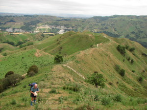
mental notes about the route and whose advice to take in the future.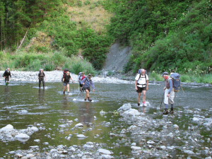 Next day we crossed the Maropea River and set off up
the very steep scrabble onto the Ruahine Drop-off that forms the first
part of the ridge to Colenso Hut and Lake Colenso (a Ruahine drop-off is
like Viv’s Kaimanawa Drop-off on steroids). The track climbs like most
Ruahine tracks, straight up a very steep ridge, 400 vertical metres to a
summit and then up and down along the ridge to a similarly steep descent.
Next is a quite exposed sidle for 30 minutes around the end of a spur to
the plateau and basin of Lake Colenso. Geologically, Lake Colenso was
formed by a slump in a limestone and Papa Clay ridge system that
subsequently filled with water to make a swamp with sufficient depth to
cover all the tree stumps. The “lake” is shallow, warm and an opaque green
due to the algae and weeds growing in the water. The surrounding bush of
the plateau has a dense flora rather reminiscent of the northland jungles
rather than the beautiful beech forest typical of the rest of the range.
Next day we crossed the Maropea River and set off up
the very steep scrabble onto the Ruahine Drop-off that forms the first
part of the ridge to Colenso Hut and Lake Colenso (a Ruahine drop-off is
like Viv’s Kaimanawa Drop-off on steroids). The track climbs like most
Ruahine tracks, straight up a very steep ridge, 400 vertical metres to a
summit and then up and down along the ridge to a similarly steep descent.
Next is a quite exposed sidle for 30 minutes around the end of a spur to
the plateau and basin of Lake Colenso. Geologically, Lake Colenso was
formed by a slump in a limestone and Papa Clay ridge system that
subsequently filled with water to make a swamp with sufficient depth to
cover all the tree stumps. The “lake” is shallow, warm and an opaque green
due to the algae and weeds growing in the water. The surrounding bush of
the plateau has a dense flora rather reminiscent of the northland jungles
rather than the beautiful beech forest typical of the rest of the range. 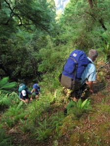 That evening a tropical depression off the east coast
brought misty rain. The Hut is situated on the left bank of the Mangatera
River. It looks out across river flats filled with budlea and lupin,
apparently flourishing due to the decline in the deer population. Iron
Bark to Colenso was about 5 hours.
That evening a tropical depression off the east coast
brought misty rain. The Hut is situated on the left bank of the Mangatera
River. It looks out across river flats filled with budlea and lupin,
apparently flourishing due to the decline in the deer population. Iron
Bark to Colenso was about 5 hours.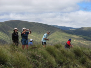 The weather was just glorious and we had fabulous
views east and north into the Ruahine Range, out across the papa clay
country of the Mangawekas, Ruapehu and Ngaruahoe and south along the Mokai
Patea towards the Ruahine high points of Hikurangi and Mangaweka. That is
what I go tramping for, and so I was in no hurry to leave the tops. It
seems that not so many others share Viv’s and my passion for the open
tops. But then I cut my teeth in the Tararuas.
The weather was just glorious and we had fabulous
views east and north into the Ruahine Range, out across the papa clay
country of the Mangawekas, Ruapehu and Ngaruahoe and south along the Mokai
Patea towards the Ruahine high points of Hikurangi and Mangaweka. That is
what I go tramping for, and so I was in no hurry to leave the tops. It
seems that not so many others share Viv’s and my passion for the open
tops. But then I cut my teeth in the Tararuas.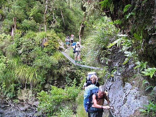 The
trip started with an email from Marianne asking for the details of my
Ruahine trip at Auckland Anniversary Weekend. A quick think returned the
germ of what looked on the map to be a nice short 2 day trip with a couple
of hours at each end to allow for the long drive down to Mangaweka and
back. After the experience in 2005, it was clear that trips needed to be
kept from being too ambitious. A tops trip in the Ruahines needs to allow
for about 4 hours continuous climbing just to get up there. This trip was
to do it twice in 2 days. The weather is always a factor in the Ruahines
as well. Then came discussions with Russell about how fit his 70 year old
friend was. No worries there, as it turned out.
The
trip started with an email from Marianne asking for the details of my
Ruahine trip at Auckland Anniversary Weekend. A quick think returned the
germ of what looked on the map to be a nice short 2 day trip with a couple
of hours at each end to allow for the long drive down to Mangaweka and
back. After the experience in 2005, it was clear that trips needed to be
kept from being too ambitious. A tops trip in the Ruahines needs to allow
for about 4 hours continuous climbing just to get up there. This trip was
to do it twice in 2 days. The weather is always a factor in the Ruahines
as well. Then came discussions with Russell about how fit his 70 year old
friend was. No worries there, as it turned out.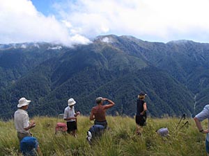
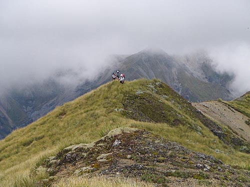 Some
of the party even had enough gas left in the tank for a 3km return trip to
Mangaweka, highest point in the Ruahines. Then it was down to Wooden Peg
and the long ridge to Purity Shelter, and water. The memory of the day was
hot sun, fabulous scenery and a real sense of achievement. The hut is
rustic to say the least but it did have a wooden floor, retrofitted
according to DOC. Very welcome it was too, because it provided good water
and the only place to put up a tent, just inside the top of the bushline.
During the night the cloud had gathered and it rained.
Some
of the party even had enough gas left in the tank for a 3km return trip to
Mangaweka, highest point in the Ruahines. Then it was down to Wooden Peg
and the long ridge to Purity Shelter, and water. The memory of the day was
hot sun, fabulous scenery and a real sense of achievement. The hut is
rustic to say the least but it did have a wooden floor, retrofitted
according to DOC. Very welcome it was too, because it provided good water
and the only place to put up a tent, just inside the top of the bushline.
During the night the cloud had gathered and it rained.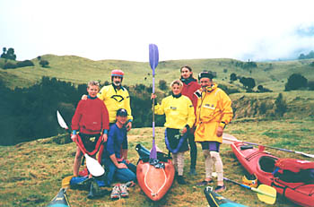 There
should be some reassurance in uncontrollable shivering. It's the body's
way of trying to warm up and as
There
should be some reassurance in uncontrollable shivering. It's the body's
way of trying to warm up and as 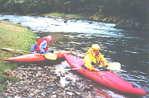 This
historic route through the Urewera National Park Ruatoki is a popular 4
day tramp. Kayaking the 76 km should take about half the time and it is
not all madness to be going in the middle of winter because in summer
there is rarely enough water for kayaks.
This
historic route through the Urewera National Park Ruatoki is a popular 4
day tramp. Kayaking the 76 km should take about half the time and it is
not all madness to be going in the middle of winter because in summer
there is rarely enough water for kayaks. 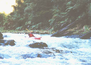 Joe
Joe
 the water goes